
Lodging Recommendations
rest up, ride out
We get it. You don’t want to simply visit Harney County—you’re ready to ride through it, hike across it, and sleep under its stars. This itinerary is built for the traveler who craves the kind of adventures that leave memories in your heart and dust, well… everywhere.
steens mountain guest ranch
With wide-open spaces, star-filled skies, and genuine cowboy grit, Steens Mountain Guest Ranch is perfect for those craving a true taste of the American West. This working cattle ranch at the base of the Steens Mountains invites you to saddle up and join the day’s work—ride through high desert terrain, help with fence repairs, or tag along on a cattle drive. A genuine high desert experience, this stay is part getaway, part immersion.
camp on the playa
Looking for a truly remote experience? The Alvord Desert offers otherworldly beauty with the cracked, white surface of the salt playa stretching endlessly below, the Steens Mountains rising to the west, and nothing but sky above. Dispersed camping is allowed almost anywhere on the playa–just be mindful of private property and other visitors. You’ll need to come prepared for hot days, cold nights, and potential high winds, and be ready to pack everything in and out. Access via Alvord Hot Springs (with a paid gate, hot springs soak, and basic amenities) or Frog Springs (free, rougher).
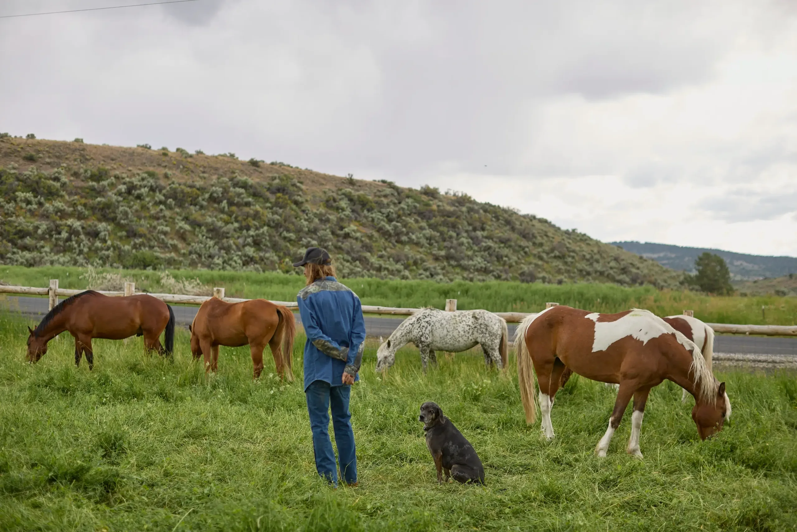
Joaquin Miller Horse Camp
Tucked in a quiet corner of Malheur National Forest, 19 miles north of Burns, Joaquin Miller Horse Camp is a quiet base camp for horseback riders and off-grid campers alike. Pipe corrals, hitching rails, and easy trail access make it horse-friendly, while the ponderosa pine setting and solitude make it special. It’s primitive, pack-in-pack-out, and seasonal—so check the website for details before you go.
Pro Tip
Start your morning at Bella Java in Burns. Their breakfast sandwiches, cozy chai, and warm vibes will get you trail-ready in no time.
ACTIVITY SUGGESTIONS
trail tested
Distance from Burns: ~2 hours
Length: 59-mile driving loop
Difficulty: Moderate to rugged
Trail use: 4×4 driving, access to hikes, scenic viewpoints
The highest drivable road in Oregon, this epic loop delivers panoramic views, wild terrain, and access to trailheads, waterfalls, and the historic Riddle Brothers Ranch. High-clearance 4×4 vehicles are required, and this road is not recommended for those inexperienced driving in the backcountry. Always check current conditions before setting out on the Steens Mountain Loop Road–late snow or washouts can make the route impassable.
Distance from Burns: ~2 hours
Length: 2.8–6.6 miles out and back
Difficulty: Moderate
Trail use: Hiking and Biking
This rugged singletrack trail winds through a canyon, past old mining ruins, and climbs steadily toward the Steens ridgeline. It’s a favorite for hikers and experienced mountain bikers, offering dramatic views of the Alvord Desert and a true backcountry feel. Expect creek crossings, about 1,600 feet of elevation gain, and some technical riding sections if you’re on wheels. Accessible via East Steens Road, it offers a peaceful wilderness escape from late spring to fall.
Distance from Burns: ~2 hours
Length: 16 miles round-trip (8 miles one-way)
Difficulty: Moderate to Challenging
Trail use: Hiking and Backpacking
The Big Indian Gorge trail journeys through a glacially carved valley in the Steens Mountain Wilderness, leading hikers through meadows, cottonwood and aspen groves, and past historic cabin ruins. Along the way, expect three creek crossings, which can be challenging during spring and early summer. The trail culminates at the headwall of the gorge, offering stunning views of waterfalls and the high desert landscape. Craving even more backcountry? Extend your adventure by climbing out of the gorge to the Steens Loop Road–a rugged option with few marked trails that we recommend only to experienced hikers. Or, combine the Big Indian Gorge Trail with the Little Blitzen Trail to form a 25.2 mile loop and bring your gear to set up camp. This multi-day loop offers a comprehensive experience of the Steens Mountain wilderness but requires careful planning and preparation.
Pro Tip
Wrap your desert adventure with a legendary burger and milkshake at Fields Station, just south of the Steens. This local favorite has earned its cult following.
Distance from Burns: ~20 minutes
Length: ~3 miles
Difficulty: Moderate
Trail Use: Hiking, Mountain Biking
Experience this 3.1-mile loop trail near Burns, Oregon. Generally considered a moderately challenging route, it takes an average of 1 h 4 min to complete. This trail is great for hiking, and it’s unlikely you’ll encounter many other people while exploring. The best times to visit this trail are April through October. Dogs are welcome, but must be on a leash.
Distance from Burns: ~2.5 hours
Length: ~4.5 miles
Difficulty: Moderate
Trail Use: Hiking and Biking
This 4.5-mile out-and-back trail makes for a great, quiet hike. On average taking around 1h 46min to complete, Bridge Creek Trail offers an abundance of bird watching opportunities, alongside plenty of other wildlife.
Distance from Burns: Varies by start point
Length: Up to 120 miles
Difficulty: Hard
Trail Use: Gravel Cycling
The Skull Gravel Grinder isn’t just a ride—it’s a full-blown endurance challenge that lives up to its name. With nearly 10,000 feet of climbing and long stretches of unpaved backroads, this desert route is best tackled by seasoned cyclists. You’ll need grit, prep, and good navigation, but the views and the solitude are next-level.
Check out the national forest website for more!
Discover the wonders of the Malheur National Forest, from towering pines to tranquil streams and abundant wildlife. Visit the official website for maps, trail guides, and tips to plan your perfect Harney County adventure.


